Ghana
SBIR Fall Armyworm
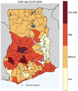
Together with Satelligence, Weather Impact has developed an early-warning system for the fall armyworm (FAW). Every Monday, a weekly FAW risk map for Ghana is calculated based on a combination of observational data, weather forecasts and satellite imagery. Our model highlights the regions in Ghana where FAW are likely to land and lay their eggs next, thereby infesting new crop fields. With our Ghanaian partner Esoko, we have set-up a pilot project to distribute the warning messages to maize farmers across Ghana and assess its impact. Esoko translates the weekly warning message in 15 local languages and communicates it to 1000 farmers per voice-SMS. At the start and the end of the pilot study, surveys are conducted to evaluate the usage and impact of our FAW early-warning system.
By informing farmers earlier on the future risk of FAW infestations, they have the possibility to prevent crop damage. Based on the risk level, farmers are (strongly) encouraged to scout their fields regularly for eggs and larvae and take precautionary measures where possible. In the end, we aim that this will result in a reduction of crop loss and a contribution to increased food security and farmers’ livelihood.
The FAW alert is now part of our Agri-Insight Service Bundle. These bundled information services provide farmers and the broader agricultural sector with insights to increase production efficiency while reducing risks at the same time. The following services are included in the Agri-Insights Service Bundle:
- Daily agri-weather forecast, to inform about upcoming weather up to 7 days ahead resulting in efficiently planned farming activities;
- Daily Fall Army Worm (FAW) alert, to receive timely risk warnings for FAW resulting in effective precautionary measures. Our FAW Alert recently won a World Bank Innovation Challenge;
- Weekly crop growth indicator, to keep track of crop growth resulting in early indication of over-/under-production.
More news about this project;
- Fall Armyworm early-warning system operational in Ghana
- First Africa, now Asia: Fall Armyworm is becoming a world-wide epidemic
- Weather Impact and Satelligence combat the Fall Armyworm in Africa
Climate risk indicators for credit scoring
Smallholder farmers have an important role in global food production. One of the challenges smallholders face is access to affordable finance. Financial institutions are reluctant to lend to smallholders due to a lack of objective and relevant information on performances and risks. For the financial services industry, smallholder farmers represent a relatively new and unexplored market segment.
In a project funded by the Dutch ING bank, Weather Impact and Satelligence have analysed the technical and financial feasibility of a reliable and scalable digital credit scoring card on smallholders, based on objective satellite data. Weather Impact particularly focused on the provision of localised and crop specific climate risk indicators. Climate risk is a combination of different meteorological factors that influence crop growth such as temperature, drought, extreme rainfall and other weather hazards. These indicators provide information about the suitability of certain areas to grow specific crops. Low weather and climate indicates a reduced credit default risk and increased eligibility to loans.
In this project, the indicators are determined for coffee and cocoa in Ghana, Indonesia and Ivory Coast. See also this movie for more information about the Impactor project of ING.