Quality of our forecasts
How we add value
Weather works differently near the equator. African rainstorms are very erratic, develop fast and on a small scale. It is therefore important to use models and algorithms that can predict these weather patterns. Weather Impacts’ high-quality forecasts are based on three sources of data: (1) the ensemble prediction system of the European Centre for Medium-range Weather Forecasting (ECMWF), which is considered the best global weather model, (2) local weather stations, (3) high quality satellite observations. These data sources allow us to deliver highly reliable weather forecasts for every location, no matter how remote. With clever algorithms we integrate knowledge from our data sources into forecasts that are tailored towards user needs, and thereby provide farmers and agribusiness with the information they need, at the right time.
- High spatial resolution (9 km)
- Precipitation probability 80% accurate for 1 week ahead*
- Available in every local language
- Based on best quality weather models, state of the art satellite data, WMO validated ground stations and crowd sourced rain observations
*70-90% depending on the location, based on more then 100 WMO validated weather stations in Africa.
Our forecasts are based on three data sources which allow us to deliver highly reliable weather forecasts for every location, no matter how remote
Our forecast vs regular weather models

The graph above shows a comparison between data from the Global Forecasting System Model (GFS) from the National Centre for Environmental Prediction (NCEP), on which a lot of free
available weather forecasts are based, and the European Centre for Medium Range Weather Forecasting (ECMWF) on which the forecasts of Weather Impact are based. The comparison is made using the Equitable Threat Score with data from the World Meteorological Organization (WMO), see also https://apps.ecmwf.int/wmolcdnv/. The Equitable Threat Score (ETS) measures the skill of a forecast relative to chance and is often used in the verification of precipitation forecasts.
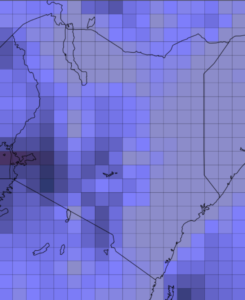
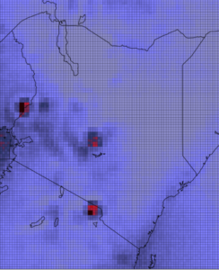
The images below shows the difference in spatial resolution over Kenya between GFS and ECMWF.
We evaluate the performance of our forecasts in collaboration with National Meteorological Agencies of various African countries. This collaboration enables us to compare our forecasts to historical archives of weather stations that are validated by the World Meteorological Organization (WMO).
Because we use ground station data in a multi-year analysis, the results of our validation are robust under seasonal variability. Furthermore, it is excluded from biases that are introduced when remote sensing or satellite data is used as a reference. Our forecast evaluation studies follow scientific international standards for validating weather forecasts.
International standards on which our work is based:
- “Recommendations on the verification of local weather forecasts”, ECMWF Technical Memoranda, Pertti Nurmi, 2003
- Guide to Agricultural Meteorological Practices (GAMP), 2010 Edition (WMO-No.134), Updated in 2012
Farmer evaluations
The usefulness and accuracy of forecasts for end-users are evaluated by our local partners via interviews and farmer testimonials.
The rainfall forecasts are rated as useful and of high quality:
100% of the farmers evaluate our rainfall forecast as useful.
96% of the farmers evaluate our forecast as very accurate or close to accurate.
“Our farmers mention that this weather
forecast is more reliable than what they
receive from other media sources.”