Myanmar
Weather Impact continues its fruitful collaboration with VillageLink, an award winning agri-tech startup in Myanmar. Together we are working on a project called “Climate and Water Smart Agriculture for Myanmar Farmers using Htwet Toe Application” within the WE4F innovation program (Water and Energy for Food). This is a follow up on the G4AW project MyVAS4Agri, where we successfully implemented weather and satellite data in information services for farmers.
Via the Htwet Toe (‘Higher Yield’) mobile application, Village Link provides 800K+ farmers with key information on weather conditions, market prices, as well as quick responses to farmers’ questions concerning farming issues, particularly pests and diseases, and ultimately access to finance. At the same time, agricultural suppliers and other data users use the platform to obtain information on farming data to enable them to more adequately meet market demand for products and services.
Our services
Weather Impact delivers weather and agro-meteorological information which can be accessed by farmers via the app. We also monitor the weather in Myanmar on a daily basis and send alerts directly to our partners at Village Link if needed. Those services support farmers to take climate-smart decisions on their farm. The app informs users about:
- Weather forecasts
- Extreme weather alerts
- The suitability of the weather for specific farm-activities, such as fertilizing or spraying;
- The weather suitability for farming activities regarding specific crops
- The favorability of the weather for the development of specific diseases;
- The climate and soil suitability of growing a crop in any location in Myanmar
Crop suitability map
The latter is displayed in a crop suitability map which is a newly developed product by Weather Impact (Figure 1). It shows the suitability of growing a certain crop (e.g. sesame, groundnut) in any location in Myanmar based on fast-changing climate data and soil parameters. For that, Weather Impact has digitized a soil map of Myanmar at a 3 km grid resolution from a detailed soil report. This way farmers are supported in their strategic decision making for the upcoming growing season.
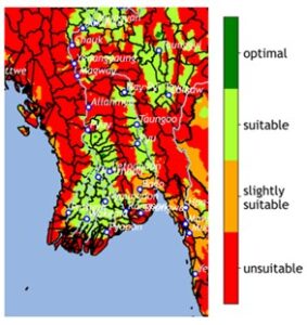
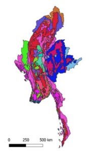
Figure 1. Crop suitability map and digital soil map.
Impact
Since the start of the project in May 2022, 30K farmers onboarded the Htwet Toe app. Up to 2.000 users access the app on a daily basis to check the latest agro-meterological advisories, whereby the number of users can grow to 5.000 farmers in case of extreme weather events. We have observed that flood warnings are one of the most important messages that farmers in Myanmar need since the country can experience several heavy rainfall events in a row (see Figure 2). We are also delighted to see that there is a positive trend in women using the app (currently 32%, Oct 22). The Htwet Toe app is growing and given that more and more services are added to the platform, this is a step into the right direction for farmers to increase their climate resilience.
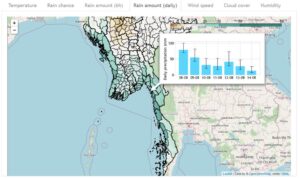
Figure 2. Daily precipitation in mm for the coming days, for a certain location in Myanmar.
More news about projects in Myanmar;
- Improving agri-weather services in Myanmar thanks to WE4F
- Onset monsoon Myanmar prospers the MyVAS4Agri project
- Two successful G4AW projects proposals
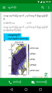
Fig.1 Htwet Toe Weather forecast on the app in Burmese.
Climate data analytics
Village Link Satellite Services (VLSS) is a platform that aggregates satellite data related to agriculture and transforms them into key information which businesses and organizations can use to improve their operations and decision making. Services on VLSS include localized weather monitoring, crop classification, crop extent measure, crop performance tracking, crop growth stage tracking and flood monitoring, all of which will benefit organizations working in the agriculture value chain; from input companies to financial service providers.
Weather Impact delivers various climate data analytics for the VLSS clients. These analytics are combined with the services of our partners in remote sensing information on the VLSS platform: SarVision and TerraSphere. Operational weather forecasts are delivered through API and contain forecasts for general weather such as precipitation, temperature, specific and relative humidity, water vapour pressure, wind speed and sunshine duration. In addition, agro-specific forecasts are accessible such as drought indictors, disease risks and an indicator of the onset of the monsoon. Weather Impact provides long term historic weather archives starting from 1979 up to now, at 5 km local precision. In addition we provide risk assessment and data analytics on this data: can significant trends be determined in precipitation and drought patterns; what is the risk of extreme rainfall or wind and how are these risks developing in a changing climate?