Fall Armyworm early-warning system operational in Ghana
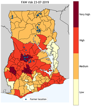
Together with Satelligence, Weather Impact has developed an early-warning system for the fall armyworm (FAW). Every Monday, a weekly FAW risk map for Ghana (Fig. 1) is calculated based on a combination of observational data, weather forecasts and satellite imagery. Our model highlights the regions in Ghana where FAW are likely to land and lay their eggs next, thereby infesting new crop fields. The risk is calculated per Ghanaian district and given in 4 classes: “low risk”, “medium risk”, “high risk”, and “very high risk”.
With our Ghanaian partner Esoko, we have set-up a pilot project to distribute the warning messages to maize farmers across Ghana and assess its impact. Esoko translates the weekly warning message in 15 local languages and communicates it to 1000 farmers per voice-SMS. At the start and the end of the pilot study, surveys are conducted to evaluate the usage and impact of our FAW early-warning system.
By informing farmers earlier on the future risk of FAW infestations, they have the possibility to prevent crop damage. Based on the risk level, farmers are (strongly) encouraged to scout their fields regularly for eggs and larvae and take precautionary measures where possible. In the end, we aim that this will result in a reduction of crop loss and a contribution to increased food security and farmers’ livelihood. When the pilot study is successful, we aim to expand the service to more farmers and more countries. According to the latest updates, FAW is already becoming a world-wide pest.